Shumar Fm
Type Locality and Naming
OUTCROP. Narayan et al. (1961) proposed this sequence as “Shumar Formation” by grouping together the conglomerate and lateritic sequences generally overlying the Eocene rocks after the type locality Shumarwali Talai. [Original Publication: Narayanan K. 1959. Progress report on the geological work in Jaisalmer, ONGC report (Unpublished)]. Reference well: Well Kharatar-2: K.B 107.68m, drilled depth 2067m and interval 00-247m. II) and well Lang-I: K.: 76.52m drilled depth 1854m and interval 00-723m.
Lithology and Thickness
Conglomerate and sandstone. The formation in the outcrop is mainly composed of conglomerate with streaks of sandstone and silty clays. The topmost surface shows lateralization. In well Kharatar-2, the formation is mainly represented by sandstone, conglomerate gravels, variegated clay and thin bed of sandy limestone. The lower part of the formation comprises fine-grained sandstone, conglomerate at places, with streaks of variegated clay and ferruginous matter. This unit grades upward to conglomerate/gravels, fine- to medium-grained sandstone with gravels to quartz, occasional thin intercalations of variegated clay and limestone streak. The succeeding litho-associations of buff to orange, hard, sandy limestone and thin intercalation of calcareous sandstone, the topmost part is of windblown sand buff to grey clayey sandstone and sandy clays. Thickness in the type section is 9.5 m (Narayan et al., 1961) whereas Dasgupta (1974) reported it around 30 m. In subsurface, it attains a thickness of 761 m in the western part of Shahgarh sub-basin (well Dangiwala-I).
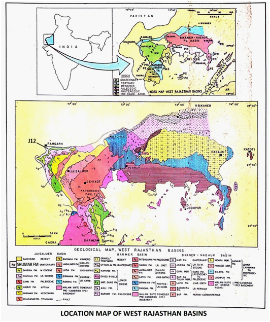
[Figure 1: Location map of West Rajasthan Basins (after Pandey and Dave, 1998)]
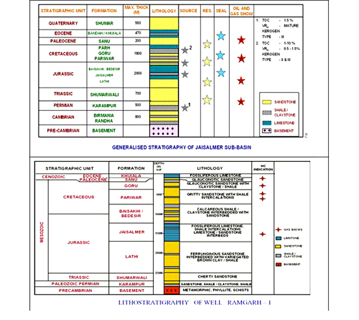
[Figure 2: Generalized and Subsurface Stratigraphy of Jaisalmer Basin (from dghindia.gov.in)]
Relationships and Distribution
Lower contact
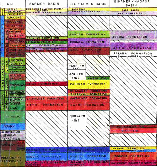
The lower boundary is unconformably overlies Bandah Fm.
Upper contact
Upper boundary is overlain by windblown recent sand dunes.
GeoJSON
Fossils
Lukose (1974) has reported some rare palynomorphs such as Tricolpites sp., Triporites sp., Tetrapoorites sp. and Tricolporites sp which do not indicate specific age.
Age
Depositional setting
Presence of conglomerate beds, gravels, coarse-grained, nodular and ferruginous sandstone often lateritic and occasional limestone bands, suggest the deposition in complex depositional environment, like fluvial, lacustrine and eolian.
Additional Information


